Using GNSS Reflectometry to map soil moisture
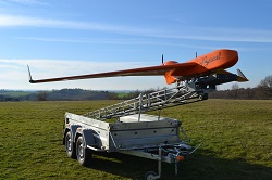
Researchers from the EU-funded MISTRALE project have designed a system which can measure soil moisture from a drone flying at low altitude using GNSS Reflectometry. The system, still a prototype, can produce high-resolution maps of soil moisture by harnessing signals from either the Galileo or GPS global satellite systems. It could help farmers make better decisions about when and where to irrigate and help water managers understand weather events such as flooding and water logging. GNSS Reflectometry, or GNSS-R, is a remote sensing technique which uses satellite signals bounced off the earth’s surface to learn about natural phenomena. In this case, the MISTRALE team have designed a system which measures direct GNSS signals coming from satellites above, and indirect signals reflected from the ground below and compares the two to learn about soil moisture. The team have also designed a GNSS-R sensor and antennas capable of tracking the satellite signals whilst on the move and fitted these to a small unmanned aircraft or drone. Developing something that was compact and lightweight was a challenge. ‘The whole system — sensor, antennas, CPU — has to weigh less than 2 kg and be as small as possible,’ says César Roda, project manager of MISTRALE and based at M3 Systems in Belgium. Futureproof device The researchers chose to make the sensor multi-frequency — it can handle signals on GPS’s L1 and Galileo’s E1 bands but also Galileo’s E5 — as a way of future-proofing the device. ‘Having a multi-frequency, multi-constellation receiver is very state-of-the-art’ says Dr Roda. ‘Applying this to GNSS-R is going to open up a lot of possibilities and allow researchers to use it for new applications.’ The first test flight, which took place over the Camargue nature reserve in Southern France in August 2015, collected 22 gigabytes of data. This has been used to finetune the processing algorithms. Additional flights over potato fields in the Netherlands, vineyards in France and an open pit mine in Spain are planned for this summer and autumn. The MISTRALE researchers are now optimising the system and expect to complete a working prototype, which can produce soil moisture maps to a resolution of 50m x 50m, by the time the project ends in late 2017. The drone, a long distance unmanned aircraft designed for research purposes, can fly for 1 000 km in a straight line or eight hours without stopping at low speed and altitude. Smart farming and flood prevention The main beneficiaries of MISTRALE are expected to be farmers who could use the information to do smart irrigation and save water. It could also be used to map flooded areas in the case of a natural disaster. Unlike earth monitoring systems, ‘we can measure the surface covered by water even through vegetation, so we can see through trees to the land underneath,’ comments Dr Roda. Water managers in charge of flood prevention could also put the MISTRALE technique to use as ‘if you know how wet the soil is, this can help inform decisions about flood prevention measures,’ concludes Dr Roda.
Keywords
MISTRALE, soil moisture, GNSS Reflectometry, high-resolution maps, smart farming, flooding, flood prevention