3D imaging unlocks mysteries beyond the ocean floor
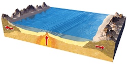
Along MORs, plates have been moving apart from each other, and an oceanic crust has been forming thanks to magmatic processes that operate within and at the base of the crust. It is believed that there is a strong link between these magmatic processes and relatively localised volcanic, tectonic and hydrothermal processes. However, the ‘characteristics of this link are largely unknown,’ says Dr Milena Marjanovic, a marine geophysicist who received a Marie S. Curie Individual Fellowship as principal researcher for the EU-funded project 3DWISE(opens in new window). ‘We examined this link and tackled fundamental and enduring questions in Earth sciences that concern mechanisms behind crustal accretion, hydrothermal circulation and submarine volcanic eruption.’ The upper crust’s poorly defined properties where the link is hosted and activity occurs is what lies at the root of the problem. Getting to the bottom of Earth’s inner layers To map these properties, 3DWISE utilised 3D full waveform inversion (3D FWI), a cutting-edge technology developed by the oil and gas industry similar to X-ray or magnetic resonance scans used in medicine. The technology was applied to the available high-fidelity seismic data sets collected along one portion of the East Pacific Rise (EPR), a MOR located along the Pacific Ocean floor. The EPR is characterised by considerable hydrothermal activity, two documented volcanic eruptions and substantial multidisciplinary time-series measurements that are unique on Earth. Once seawater penetrates the crust, there’s insufficient knowledge about its hydrothermal pathways and how it interacts with other crustal processes. Scientists examined the nature of zero-age crust formed at the EPR from 9 º16’N to 9 º56’N using modern geophysical techniques. They imaged low-velocity irregularities and associated them with the presence of up-going and down-going hydrothermal pathways within the axial plane of the fast spreading ridge. Project partners then compared results with the available data sets. Findings show that the interaction between the tectono-magmatic and hydrothermal processes is not straightforward because of the different timescales at which they operate. In addition, they found that the high crustal permeability and high thermal regime must coexist in time and space for developing, maintaining and driving vigorous, high-temperature hydrothermal flow. The upper part of the crust formed at the EPR is represented by basalts (layer 2A) and dikes (2B). In velocity models, the layer 2A/2B boundary is characterised by a velocity gradient, which is attributed to change in porosity. The geologic nature of the gradient is debated. Due to limited information on the upper crustal velocities, it’s unclear if this observation is due to the extrusive layer’s physical thickening or because of a downward propagating, hydrothermally driven, cracking front. Team members applied an elastic 3D FWI method to a 3D seismic data set collected at the EPR. Results indicate that the emplacement of extrusives, variation in their thickness and rate of dike subsidence are predominantly controlled by tectono-magmatic features and processes operating near the ridge axis. Capturing ground breaking 3D images of the ocean’s upper crust In addition, 3DWISE provided a proper 3D image of the axial magma lens that rests at about 1.5 km below the seafloor and is about 1 km wide. According to Dr Marjanovic, this is the first time a 3D high-resolution image of the oceanic crust’s upper portion has been obtained. Understanding the formation of crusts at the origin of oceanic plates will provide better insight into plate behaviour farther from the ridge axis and at subduction zones. ‘These zones are particularly important because they’re the places where large earthquakes and devastating tsunamis began, some of which are considered the worst disasters in human history,’ concludes Dr Marjanovic.