Satellite data powers water use compliance monitoring
Climate change is causing disruptions to water cycle patterns, while growing demand from agriculture and other sectors is putting huge stress on this critical resource. Careful monitoring and management, especially in regions of scarcity, has never been more important. The EU-funded WaterSENSE(opens in new window) project sought to help water managers with a tool that combines Earth observation (EO) data with hydrological models, as well as local data. In doing so, the project team hoped to provide more accurate mapping of water availability and ensure compliance with water regulations.
Addressing water usage and compliance
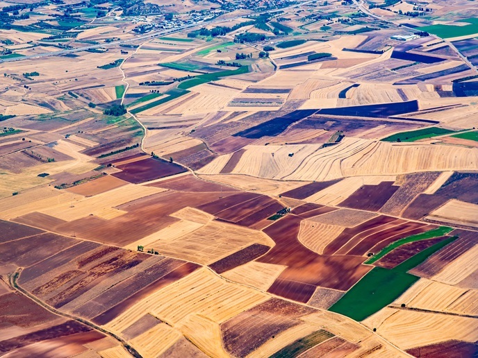
“A key focus of the project was on Australia,” explains WaterSENSE project manager Steven Wonink from eLEAF(opens in new window) in the Netherlands. “The reasons for this are that the country has serious drought challenges, and it is also very advanced with regards to policy.” Wonink points out that the state of New South Wales (NSW) – a state 20 times larger than his native Netherlands – has legislation that requires farmers and other water users to buy licences. These quantify the amount of water they can take. “The challenge is that it is incredibly difficult to enforce this legislation over such a large area,” he says. “It is hard to track who is using the water, whether this is legal, and who owns which permit.”
Applying EO and modelling data
To address this, a compliance monitoring tool was developed using EO data from Copernicus(opens in new window) satellites, in situ measurements and advanced hydrological models. “Although AI was not at the heart of this project, we saw a growing focus on AI as the technology developed,” adds Wonink. “For example, we used it in our data processing, to identify and mask cloud cover.” The tool was trialled in Australia’s Murray-Darling Basin – a significant agricultural area – and demonstrated capability to estimate the amount of water being applied to individual fields. A great deal of complexity however involved matching EO and modelling data with regulatory compliance data. For this, the team worked together with a demonstration partner, the NSW Department of Climate Change, Energy, the Environment and Water. A database of licence users and holders – which were not always the same – was built and integrated with water usage data. The project also focused on measuring environmental flows to help authorities understand how much water is needed to maintain a natural ecosystem. Project partners also looked into developing specific services for cotton farmers.
Improving water use in the cotton industry
Following successful testing of the concept in Australia, the project team is continuing as a consortium to bring the technology closer to market. The aim is to expand and improve the toolbox and tailor it more to specific user needs. “The work of WaterSENSE is being continued in a new EU-funded project called REINFORM,” says Wonink. “In this project, we are specifically focusing on improving water use in the cotton industry. Our aim as a consortium is to be able to deliver a broad array of services to clients down the line. This technology can be applied anywhere in the world.” Moving forward, Wonink believes that the data analysis capabilities of AI will continue to be harnessed and grow in importance. “What we have seen in WaterSENSE is that one approach doesn’t give you the complete picture,” he notes. “There are multiple ways to estimate water use. AI can improve data quality and accuracy, in particular when it comes to analysing uncertainty.”