The Arctic ice from above
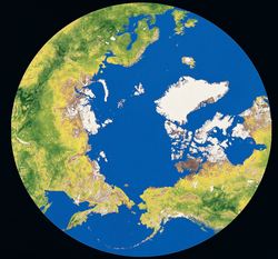
Over the past summers, the Northeast Passage (leading from the Russian island Novaya Zemlya, off the northern shore of Siberia, through the Bering Strait between Alaska and eastern Russia), has been ice-free. While a new sailing route has opened up, the melting of the Arctic ice cap also indicates the seriousness of climate change. The numerous satellites in orbit around Earth offer a new way to enhance the monitoring of sea ice, icebergs and glaciers in the Arctic. The EU-funded project MAIRES(opens in new window) (Monitoring Arctic land and sea ice using Russian and European satellites) demonstrated the benefits of combining high-resolution radar data and images for mapping and forecasting land and sea ice in the Eurasian Arctic. Specifically, the European Space Agency (ESA) has developed leading capacity in Earth observation through the Environmental Satellite (ENVISAT) and Cryosphere Satellite (CRYOSAT) missions. Researchers combined data from these satellites with Canadian, Russian and United States satellite data to disclose recent changes in Arctic ice cover. Starting with synthetic aperture radar data, optical and infrared images, and passive microwave data among others, researchers developed new methodologies to monitor Arctic glaciers, sea ice and icebergs. The derived data products can contribute to a better understanding of climate change, providing scientists with critical information. During the course of the project, researchers modernised the technique for combining radar interferometry and light detection and ranging altimetry to measure glacier elevation changes in semi-automatic mode. Apart from high sensitivity to changes in glacier topography and independence of natural illumination, the major advantage of the so-called dual-sensor INSARAL technique is glacier-wide coverage and precision. This technique forms the basis for the reliable modelling of topographic changes in glacier accumulation areas – even in the case of relatively sparse coverage. A major achievement has been a suite of statistical models for the largest glaciers in the Arctic, including Vestfonna-Ahlmanfonna (2 500 km2) in Svalbard and several smaller ones. MAIRES research has led to valuable new data on Arctic glaciers and the cryosphere. Detailed interpretation of observed changes is necessary to identify the driving forces that shape the present land and sea ice accumulation. Still, the data can make a key contribution to the development of accurate predictions of snow and ice fluctuations in the near future.