Modelling ocean flows advances climate change understanding
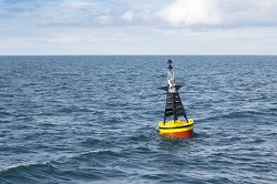
With oceans covering more than 70 % of the Earth’s surface, and their flows and movements are key to understanding and predicting the effects of climate change. More and more data is being collected about our oceans and now the challenge is to make sense of it all. EU-funded project OCEANDATAMODELS has developed new methods to analyse the large amounts of data collected by specialist floating instruments that track the trajectories of ocean water particles. ‘Our key innovation was to build new statistical models and analytical tools capable of capturing the swirling rotational oscillations caused by the Earth’s rotation – the Coriolis Effect - as well as effects from tides and their counter-currents known as Eddies, and water turbulence,” says Sofia Olhede, OCEANDATAMODELS project coordinator and Professor at University College London (UCL). The models of ocean water particle pathways now form part of the vast body of statistical techniques used by climate scientists to improve our understanding and ability to predict climate change. Satellite-tracked drifters Project researchers used reams of data from the US’s National Oceanic and Atmospheric Administration which has gathered hundreds of millions of observations on currents, sea surface temperature, atmospheric pressure, winds and salinity over the past 40 years under its Global Drifter Programme. The data was collected by ‘drifters’ – or free-floating satellite-tracked buoys that monitor the motion of water particles at the ocean’s surface, allowing scientists to closely monitor the ocean’s overall circulation. ‘The challenge of modelling the motion of drifters is that the data moves in both time and space - something we call a “Lagrangian” perspective - and these types of data required us to develop a new toolkit of statistical and data science methodology,’ explains Dr Adam Sykulski, Lead Research Fellow on the project at Lancaster University. The project built innovative statistical models, using a cross-disciplinary approach from both statistics and oceanography. Researchers could then map how our oceans vary across time and space, exploring factors like the swirl of currents around the Equator and how water particles from different oceans mix and travel around the world. One example of the modelling undertaken by researchers is a ‘spaghetti plot’ diagram of drifters as they travel the world. The different paths drifters can take helps scientists to determine how quickly and in what way the ocean is mixing and moving. The models developed by OCEANDATAMODELS are not only used by climate change scientists, but are also utilised to track and understand the movement of environmental challenges such as oil spills, and the movement of animal species, such as plankton, across the world’s oceans. The project results have now been published in a range of scientific journals and some data is publicly available to download from the Global Drifter Program website(opens in new window). The modelling techniques developed by OCEANDATAMODELS can also be applied to other fields including analysis of seismic signals, neuroscience, glaciology and ecology. Meanwhile, Olhede says that a possible next step for project researchers could be to extend the current model from its current two-dimensional surface data approach, to develop a model for three-dimensional data covering the ocean’s depth.